Matin Forutan
Geospatial engineer seeking a PhD in Web GIS
M.Sc. in GIS, K. N. Toosi University of Technology · based in Italy
Sixteen years in energy and GIS, most of them building enterprise GIS in Iran's gas industry, from pipeline data models to a Web GIS used by 21 regional companies. I now want to study the questions that work raised.
- in energy and GIS
- 16 years
- users of IGN, the Web GIS I coordinated
- 10,000
- of pipeline in one geodatabase
- 5,021 km
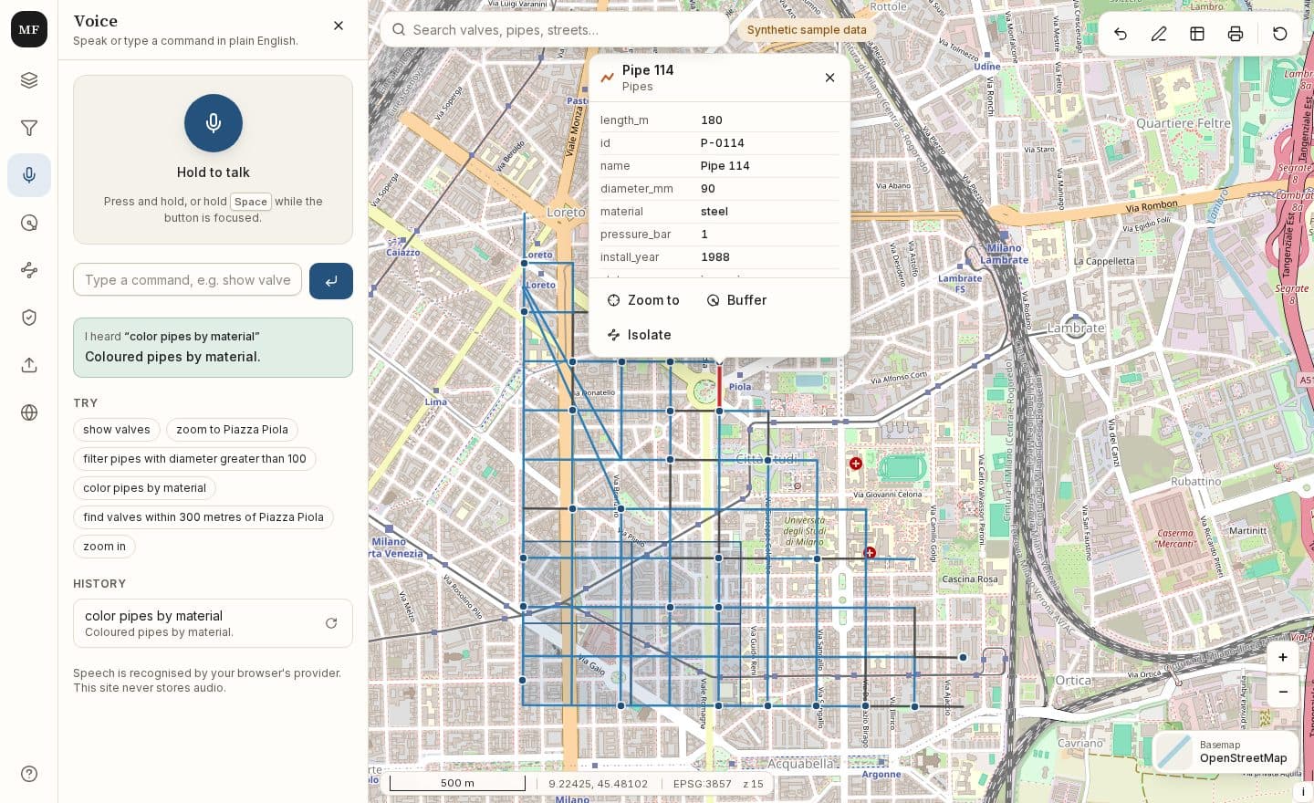
Map lab: an open-source Web GIS prototype
Query, voice commands, network tracing and topology checks on a synthetic network.
Research fit
Research backgroundMy interests: Web GIS and voice-based interfaces for geospatial data; Multi-source spatial data integration and open geospatial platforms. These questions come from my work:
- 1
Integrating data from many sources (satellite imagery, legacy maps, new surveys) into one consistent geodatabase, and keeping its quality, is a problem I met at work and would like to study properly.
- 2
How users of a large Web GIS search for and query data is a question I met while defining requirements for an enterprise platform, and I would like to study it with proper research methods.
Evidence:Enterprise Web GIS for 10,000 usersVoice commands in the lab
- 3
Open, standards-based platforms versus proprietary ones is a comparison I worked through in a feasibility study, and I would like to understand it more deeply.
What I want from a PhD: research methods and the habit of a careful question; depth in one area, shaped with a supervisor; publishing; contributing to a research group's existing projects.
Selected work
Full case studiesA 5,021 km geodatabase
A standardized as-built data model (104 layers), a 5,021 km unified geodatabase with QA/QC and acceptance standards, and a data model for basic and detailed design.
5,021 km, 104 layers, 40 contractor staff trained over 60 hours.
Enterprise Web GIS for 10,000 users
Functional specifications for the Web GIS services and for semantic voice search, and a rollout kept on budget and schedule with the open-source stack (GeoNode, GeoServer, OGC services).
10,000 users, 21 regional companies, about 200 stakeholders.
An open-source feasibility study
A documented comparison of cost, interoperability, and vendor lock-in, used when the open-source stack was later adopted.
The study covered the same families of tools the prototype uses: GeoServer, QGIS, and PostGIS.
Experience
All details- Oct. 2023 – Aug. 2026Head of GIS DepartmentIranian Gas Engineering and Development Company
- Led a five-person team that set the roadmap for preparing pipeline as-built maps and moving the company toward the IGN enterprise GIS: translated National Iranian Gas Engineering and Development Company requirements into a standardized as-built data model (104 layers), built a 5,021 km unified geodatabase with QA/QC and acceptance standards, and trained 40 contractor staff (60 hours).
- Led a team that integrated pipeline data from multiple sources (satellite imagery, legacy maps and new maps) into the unified geodatabase, and defined the data integration standards with NIGTC.
- Initiated a needs assessment and feasibility study for deploying IGN, and led a team that identified all pipeline design data (basic and detailed design, including line and environmental data) and prepared their data model.
Aug. 2021 – Oct. 2023GIS Project CoordinatorNational Iranian Gas Company
Managed IGN, an enterprise GIS platform and decision support system for gas network data (10,000 users, 21 regional companies).
Jun. 2018 – Aug. 2021GIS Senior Data and Business AnalystNIGC
Planned the feasibility and development of two software platforms (IGN and GPNET) and specified their requirements.
May 2014 – Jun. 2018Senior GIS SpecialistNIGC
Designed spatial databases and administered ArcGIS Server / ArcGIS Pro.
Feb. 2012 – May 2014GIS & IT Researcher and SpecialistNIGC
Led a feasibility study benchmarking proprietary GIS platforms against GeoServer, QGIS and PostGIS.
Mar. 2010 – Feb. 2012Business and Data AnalystParsineh Tarhe Aatieh Company
Coordinated the Web GIS project for agricultural beneficiaries of Golestan Province.
Sep. 2008 – Mar. 2010Graduate Research AssistantKNTU
Member of a KNTU research team for the assessment, feasibility study, design and implementation of GIS.
Education
Honours and teachingM.Sc. in Geospatial Information Systems (GIS)
K. N. Toosi University of Technology (KNTU), Tehran, Iran · 2007 – 2009
GPA 19.11/20. Highest-ranking student. Thesis: “Mineral Potential Mapping Using Artificial Neural Networks.”
B.Sc. in Geomatics Engineering
K. N. Toosi University of Technology, Tehran, Iran · 2003 – 2007
GPA 17.03/20. Highest-ranking student.
Ranked first in both degrees, and best researcher in Geomatics Engineering at KNTU in 2010.
Publications
Full citationsMy papers come from my M.Sc. research and the years just after it. Since then I have worked in industry, and the questions above come from that work.
2011
Comparing the performance of MLP, RBF, PNN and GRNN neural networks for determining boreholes of porphyry copper in GIS
Geosciences Scientific Quarterly Journal · ISI indexed
2013
Determining the optimum position of boreholes using Hyperion image and neural networks method
Journal of Geospatial Information Technology (JGIT)
2010
Determination of optimum mineral zones using artificial neural networks
Geomatics 89 Conference and Exhibition, Iranian National Cartographic Center (NCC) · Best Student Paper
2009
Site selection of optimum fire station using artificial neural networks
Geomatics 88 Conference and Exhibition, Iranian National Cartographic Center (NCC)
2008
An architecture for navigating vehicles for urban services
Geomatics 87 Conference and Exhibition, Iranian National Cartographic Center (NCC)
2008
The application of GA in shortest path finding using weighted parameters
Geomatics 87 Conference and Exhibition, Iranian National Cartographic Center (NCC)
Skills
Core
- QGIS
- PostGIS
- GeoServer
- GeoNode
- OGC services (WMS, WFS, WCS)
- Spatial data modelling and SDI
- Multi-source data integration (ETL)
- Spatial analysis
- ArcGIS Pro
- Python
- GIS programme management (PMP)
Also used
- ArcGIS Server
- GeoNetwork
- GE Smallworld
- AutoCAD Map 3D
- OpenStreetMap
- Oracle Spatial
- SQL Server Spatial
- ENVI
- ERDAS
- Machine learning / ANN (MATLAB)
- JavaScript
- Node.js REST APIs
- Azure DevOps
- Project planning and control
- Contract and vendor management
Languages
- Persian
- Native
- English
- C1 (IELTS 7, 2019)
- Italian
- A2
- German
- A2

